How to show vehicle direction of travel in an accident diagram
Published: 2026-08-07 · Updated: 2026-08-18
Written and reviewed by the My Traffic Sketch editorial team · How our guides are made
Many conversations about a collision come back to one question: who was moving where? A diagram that shows direction of travel clearly answers it in seconds; one that leaves it ambiguous invites confusion. Here is how to get it right.
One arrow per vehicle, attached to the vehicle
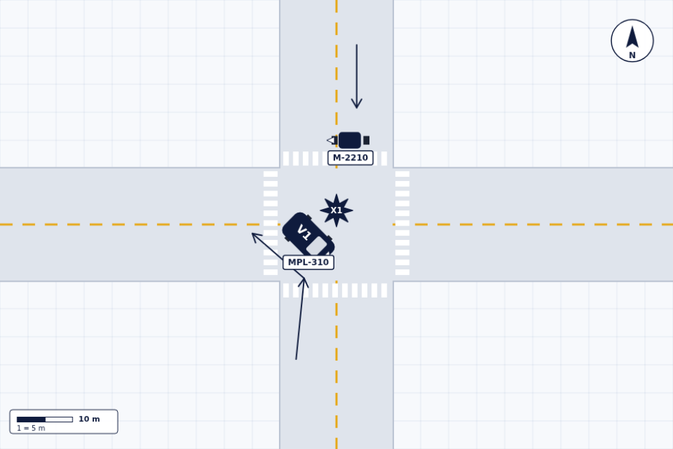
Draw each vehicle's travel arrow starting at or just behind the vehicle, pointing along its actual path. An arrow floating in a lane is ambiguous. Attached to V1, it is V1's testimony.
The vehicle's own orientation must agree with its arrow. A car pointing north with an arrow pointing west reads as an error and undermines the whole diagram.
A worked example: braking before the impact
Consider a simple scenario (all values illustrative): V1 approaches an intersection eastbound and begins braking approximately 12 m before the impact point X1, leaving a visible skid. V2 is northbound, entering from V1's right. To show this clearly, V1 gets a straight arrow along the eastbound lane, a skid line drawn from where the mark begins to where V1 stopped, and a labeled measurement ("approx. 12 m") on that skid: while V2 gets its own arrow crossing V1's path, and X1 sits at the crossing point.
Someone reading that diagram now sees the sequence without a word of narrative: V1 was moving east, saw something, braked hard for a car length or three, and the paths met at X1. The arrows carry the motion; the skid and its measurement carry the timing. That is the level of story a direction arrow can tell when it works together with the other elements.
Show the path, not just the heading
For turns and lane changes, a curved arrow tracing the actual path says far more than a straight one. In My Traffic Sketch, draw the path with the arrow tool in segments, or use the pen for a freehand curve. Then place the vehicle at the point of impact along that path.
Four patterns cover most collisions:
- ▸Straight travel: one straight arrow behind the vehicle, along the lane.
- ▸A turn: one curved arrow following the turning path from the approach lane into the exit lane: not two disconnected straight arrows.
- ▸A lane change: a shallow S-shaped arrow from the original lane into the new lane, started well before the impact so the drift is visible.
- ▸Backing: a short arrow pointing away from the rear of the vehicle. Slow movement is still movement — 'backing at walking speed' has a direction.
Intended maneuver vs. actual movement
"V1 was turning left" (intent) and "V1 traveled straight through the intersection" (movement) can both be true in sequence. When intent matters, note it in the narrative and reserve the arrows for what physically happened. Never draw an arrow for a movement that did not occur.
The same discipline applies after the impact. If vehicles moved between impact and rest — spun, rolled forward, were pushed — the arrows show the pre-impact travel, and the rest positions belong either in the narrative or as clearly marked second outlines. Mixing pre- and post-impact motion in the same set of arrows is the fastest way to make a diagram argue with itself.
Common arrow mistakes
Watch for the errors that quietly break a diagram:
- ▸No arrows at all. Two touching rectangles with no motion is a picture, not an account.
- ▸Arrows drawn against the vehicle's orientation, so the car appears to travel sideways or backward unintentionally.
- ▸One shared arrow for two vehicles 'because they were both going the same way' — each vehicle testifies separately.
- ▸Arrows that start at the impact point, which makes the collision look like the origin of travel rather than its end.
- ▸Decorative arrows for uninvolved traffic, which bury the two arrows that matter.
Direction needs a compass
"Northbound" only means something if the diagram shows north. Drag the compass in the editor so it matches the real orientation of the scene, and the words in your narrative and the arrows in your diagram will finally agree.
This is also the detail that makes your diagram agree with the outside world: the street names on the exported sheet, the narrative's "V1 eastbound", and anyone comparing the sketch against a map all rely on that one compass being right. Set it early: rotating north after everything is drawn invites exactly the inconsistency you were avoiding.
Ready to draw your own diagram? The editor is free and needs no account.
Open the free sketch tool